

INDO-BANGLADESH WATER TREATY
Farakka is three hundred and fifty kilometres,
as the crow flies, due north of Kolkata: important fact number two. As far
back as 1852, the East India Company was concerned about the long-term viability
of the port of Kolkata. It was silting up, I presume, for normal hydrological
reasons. Sir Arthur Cotton, a leading company engineer, suggested diverting
Ganga down into the Hugli, to flush the silt out to sea. The idea was studied,
then rejected. The Bengal Chamber of Commerce took it up in the 1930s, and
again rejected it. I would love to know the reasons. Cost? Feasibility? Hydrological
consequences? Whatever the reasons the Indian government decided to go ahead
in the 1960s. Was it to punish Pakistan? They’d done this before: in
1948 as tit-for-tat for Kashmir, India shut off the water flowing from the
Firozpor head works into Pakistan’s Dipalpur Canal. What we now call
Bangladesh was then East Pakistan. So it sounds plausible.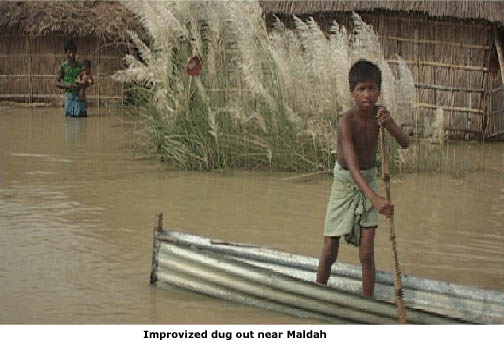
Kolkata was of prime strategic and economic
importance to India. The Hugli was obviously silting up and boats were getting
larger and their drafts deeper. So they dusted off the plans and took the
decision to build a barrage across the Ganges to divert low season flow through
a feeder canal down the Bhagirathi-Hugli and ‘flush’ the river
at Kolkata.
Before 1947, the old rail and road links from Bengal to Assam were via the
Hardinge Bridge, now thirty kilometres inside Bangladesh (but at that time
the arch enemy - East Pakistan). It would have cost a lot to divert both the
railway line and National Highway 34 from Murshidabad District over to Birbhaum
and up to Rajmahal; it did not make geographic, strategic, or economic sense.
And on the other side? It was far more convenient to divert the pre-1947 rail
and road links a few kilometres west and resume their path up into Assam.
Farakka was the obvious place.
What is interesting are the basic questions
they did not address.
Was the amount of water coming down into the Hugli already in decline? Could
there be other reasons why Kolkata was silting up? Would an increase in water
from Ganga into Hugli really ‘flush’ the port of Kolkata and keep
the Hugli open? Were there cheaper options, such as moving the port downstream?
And what about the impact on Bangladesh?
The Indian government studied the project for
a full twenty years, from 1951 to 1971. Pakistan protested but could do nothing.
Then New Delhi finally made up its mind. They would build Asia’s longest
barrage on alluvial soil. They would divert Ganga down a feeder canal just before
the barrage, increase the flow of water into Bhagirathi-Hugli, flush the silt
out of Kolkata and keep the port open to shipping. Put like this it sounds eminently
reasonable.
 They went ahead, built and commissioned the barrage
(1971–75) in the absence of any international agreement. Unfortunately,
western Bangladesh is vitally dependent on Ganga in the winter months. So in
the flush of Bangladeshi independence from Pakistan, a short-term agreement
between India and Bangladesh was signed in 1977. But it was very short-term,
and it wasn’t until 1996 that a permanent treaty was signed, that has
worked more or less well.
They went ahead, built and commissioned the barrage
(1971–75) in the absence of any international agreement. Unfortunately,
western Bangladesh is vitally dependent on Ganga in the winter months. So in
the flush of Bangladeshi independence from Pakistan, a short-term agreement
between India and Bangladesh was signed in 1977. But it was very short-term,
and it wasn’t until 1996 that a permanent treaty was signed, that has
worked more or less well.
The Ganges Water Treaty is far from perfect but
it makes sense. The two countries get to share Ganga according to a sliding
scale that favours one or the other country according to the time of year. In
1977, the winter flow hit an all-time low. There wasn’t too much water
to share. Eventually, each country got half of the reduced flow, but neither
was happy.
Bangladesh always wants to increase its share
of the flow. So it periodically suggests regional cooperation with India and
Nepal. However, trilateral talks with India and Nepal have always failed because
India has resisted. The others want India to put up much of the finance. India
balks. Instead, India proposes boosting the flow of Ganga at Farakka by diverting
part of the Brahmaputra from Assam. After all, it’s part of India. But
this would mean building a canal half a mile wide and more than one hundred
kilometres long across Bangladeshi territory with both significant control points
on Indian soil and in Indian hands. It would therefore be unacceptable to Bangladesh.
Graham maintains it’s a non-starter anyway because the canal would have
to be brought over the Teesta river, which is about as stable as the Kosi!
Bangladesh blames Farakka for everything. The
main complaint is that the lack of adequate flow has caused salt water to creep
up a hundred kilometres into the Sundarbans from the Bay of Bengal. This increase
in salinity is then blamed for the alleged death of the mangrove forests. It
sounds plausible until you remember that mangroves thrive on brackish water.
What if the problems of the Sundarbans have other manmade causes such as the
pressure on land and water from substantial population increase? Misguided encouragement
of water intensive crops? Or expansion of irrigation via shallow tube wells
that lowers the water table?
Maps:
Ganga in Bihar
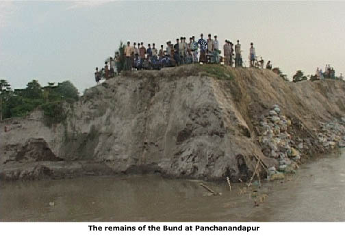
Farakka
Farakka insert
Side texts:
Being Stateless
Maldah
Hugli
Indo-Bangladesh Treaty
©,
2007 Independent Broadcasting Associates, Inc |